spectrochempy.Coord
- class Coord(**kwargs)[source]
Explicit coordinates for a dataset along a given axis.
The coordinates of a
NDDatasetcan be created using theCoordobject. This is a single dimension array with either numerical (float) values or labels (str,Datetimeobjects, or any other kind of objects) to represent the coordinates. Only a one numerical axis can be defined, but labels can be multiple.- Parameters
data (ndarray, tuple or list) – The actual data array contained in the
Coordobject. The given array (with a single dimension) can be a list, a tuple, andarray, or andarray-like object. If an object is passed that contains labels, or units, these elements will be used to accordingly set those of the created object. If possible, the provided data will not be copied fordatainput, but will be passed by reference, so you should make a copy thedatabefore passing it in the object constructor if that’s the desired behavior or set thecopyargument to True.**kwargs – Optional keywords parameters. See other parameters.
- Other Parameters
dtype (str or dtype, optional, default=np.float64) – If specified, the data will be casted to this dtype, else the type of the data will be used.
dims (list of chars, optional.) – if specified the list must have a length equal to the number od data dimensions (ndim) and the chars must be taken among among x,y,z,u,v,w or t. If not specified, the dimension names are automatically attributed in this order.
name (str, optional) – A user friendly name for this object. If not given, the automatic
idgiven at the object creation will be used as a name..labels (array of objects, optional) – Labels for the
data. labels can be used only for 1D-datasets. The labels array may have an additional dimension, meaning several series of labels for the same data. The given array can be a list, a tuple, andarray, a ndarray-like, aNDArrayor any subclass ofNDArray.units (|Unit| instance or str, optional) – Units of the data. If data is a
Quantitythenunitsis set to the unit of thedata; if a unit is also explicitly provided an error is raised. Handling of units use the pint package.title (str, optional) – The title of the dimension. It will later be used for instance for labelling plots of the data. It is optional but recommended to give a title to each ndarray.
dlabel (str, optional) – Alias of
title.copy (bool, optional) – Perform a copy of the passed object. Default is False.
linear (bool, optional) – If set to True, the coordinate is considered as a
LinearCoordobject.offset (float, optional) – Only used is linear is True. If omitted a value of 0.0 is taken for the coordinate offset.
increment (float, optional) – Only used if linear is true. If omitted a value of 1.0 is taken for the coordinate increment.
See also
NDDatasetMain SpectroChemPy object: an array with masks, units and coordinates.
LinearCoordlinear coordinates.
Examples
We first import the object from the api :
>>> from spectrochempy import Coord
We then create a numpy
ndarrayand use it as the numericaldataaxis of our newCoordobject :>>> c0 = Coord.arange(1., 12., 2., title='frequency', units='Hz') >>> c0 Coord: [float64] Hz (size: 6)
We can take a series of str to create a non numerical but labelled axis :
>>> tarr = list('abcdef')
>>> tarr
['a', 'b', 'c', 'd', 'e', 'f']
>>> c1 = Coord(labels=tarr, title='mylabels')
>>> c1
Coord: [labels] [  a   b   c   d   e   f] (size: 6)
Methods
Coord.amax(dataset[, dim, keepdims])Return the maximum of the dataset or maxima along given dimensions.
Coord.amin(dataset[, dim, keepdims])Return the maximum of the dataset or maxima along given dimensions.
Coord.arange([start, stop, step, dtype])Return evenly spaced values within a given interval.
Coord.around(dataset[, decimals])Evenly round to the given number of decimals.
Coord.astype([dtype])Cast the data to a specified type.
Coord.copy([deep, keepname])Make a disconnected copy of the current object.
Coord.fromfunction(cls, function[, shape, ...])Construct a nddataset by executing a function over each coordinate.
Coord.fromiter(iterable[, dtype, count])Create a new 1-dimensional array from an iterable object.
Coord.geomspace(start, stop[, num, ...])Return numbers spaced evenly on a log scale (a geometric progression).
Coord.get_labels([level])Get the labels at a given level.
Coord.is_units_compatible(other)Check the compatibility of units with another object.
Coord.ito(other[, force])Inplace scaling to different units.
Inplace rescaling to base units.
Quantity scaled in place to reduced units, inplace.
Coord.linspace(cls, start, stop[, num, ...])Return evenly spaced numbers over a specified interval.
Coord.loc2index(loc)Return the index corresponding to a given location.
Coord.logspace(cls, start, stop[, num, ...])Return numbers spaced evenly on a log scale.
Coord.max(dataset[, dim, keepdims])Return the maximum of the dataset or maxima along given dimensions.
Coord.min(dataset[, dim, keepdims])Return the maximum of the dataset or maxima along given dimensions.
Coord.ptp(dataset[, dim, keepdims])Range of values (maximum - minimum) along a dimension.
Coord.round(dataset[, decimals])Evenly round to the given number of decimals.
Coord.round_(dataset[, decimals])Evenly round to the given number of decimals.
Coord.to(other[, inplace, force])Return the object with data rescaled to different units.
Coord.to_base_units([inplace])Return an array rescaled to base units.
Coord.to_reduced_units([inplace])Return an array scaled in place to reduced units.
Attributes
True if the
dataarray is dimensionless - Readonly property (bool).Data type (np.dtype).
Current filename for this dataset (
Pathlibobject).True if the
dataarray is not empty and size > 0.True is the name has been defined (bool).
True if the
dataarray have units - Readonly property (bool).Object identifier - Readonly property (str).
True if the
dataarray is empty or size=0, and if no label are present - Readonly property (bool).True if the
dataare real values - Readonly property (bool).True if the
dataare integer values - Readonly property (bool).True if the
dataarray have labels - Readonly property (bool).Range of the data (list).
Flag to specify if the data can be constructed using a linear variation (bool).
Additional metadata (
Meta).A user-friendly name (str).
Starting value for linear array
bool - Whether the axis is reversed (readonly property).
Region of interest (ROI) limits (list).
Size of the underlying
dataarray - Readonly property (int).Return coordinates spacing.
An user friendly title (str).
The actual array with mask and unit (
Quantity).bool- True if thedatadoes not haveunits(Readonly property).Unit- The units of the data.Alias of
values.Quantity- The actual values (data, units) contained in this object (Readonly property).- data
-
If there is no data but labels, then the labels are returned instead of data.
- dtype
Data type (np.dtype).
- filename
Current filename for this dataset (
Pathlibobject).
- has_defined_name
True is the name has been defined (bool).
- has_units
True if the
dataarray have units - Readonly property (bool).See also
unitlessTrue if the data has no unit.
dimensionlessTrue if the data have dimensionless units.
- id
Object identifier - Readonly property (str).
- is_empty
True if the
dataarray is empty or size=0, and if no label are present - Readonly property (bool).
- labels
An array of labels for
data(ndarrayof str).An array of objects of any type (but most generally string), with the last dimension size equal to that of the dimension of data. Note that’s labelling is possible only for 1D data. One classical application is the labelling of coordinates to display informative strings instead of numerical values.
- limits
Range of the data (list).
- linear
Flag to specify if the data can be constructed using a linear variation (bool).
- m
-
If there is no data but labels, then the labels are returned instead of data.
- magnitude
-
If there is no data but labels, then the labels are returned instead of data.
- meta
Additional metadata (
Meta).
- name
A user-friendly name (str).
When no name is provided, the
idof the object is returned instead.
- offset
Starting value for linear array
- reversed
bool - Whether the axis is reversed (readonly property).
- roi
Region of interest (ROI) limits (list).
- spacing
Return coordinates spacing.
It will be a scalar if the coordinates are uniformly spaced, else an array of the different spacings
- title
An user friendly title (str).
When the title is provided, it can be used for labeling the object, e.g., axe title in a matplotlib plot.
- umasked_data
The actual array with mask and unit (
Quantity).(Readonly property).
- units
Unit- The units of the data.
- values
Quantity- The actual values (data, units) contained in this object (Readonly property).
Examples using spectrochempy.Coord
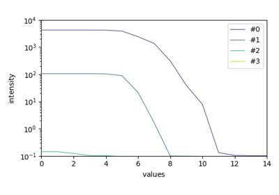
EFA analysis (Keller and Massart original example)
